Discover by Bus
Pay for Auckland public transport your way. You can use your AT HOP card, contactless debit card, credit card, smartphone or smartwatch. Each person travelling must tag on and off with their own contactless card or smart device, so you will not be able to pay for someone else using a contactless method. You can use your AT HOP card to pay for another person, just let your bus driver know when you board.
AT HOP cards can be purchased at specific retailers below. Or you can now buy a pre-loaded AT HOP card from a vending machine for $25. This includes $20 of travel credit and can be found at:
Auckland Domestic Airport
Auckland International Airport
Downtown Ferry Terminal
Devonport Ferry Terminal
Event Journey Planner
Tickets to some events may include free public transport. To find out whether your event ticket includes free travel, visit Auckland Transport’s event information.
Walk - 3 mins
250m to Bus Stop A: Mt Eden & Balmoral Interchange
27H / 27W Bus towards Britomart
Exit bus at Mt Eden Village. 3 mins (After 2 stops)
Walk - 2 mins
Bus Stop: Valley Road International Church
64 Bus towards St Lukes
Exit bus at Eden Park. 6mins (After 4stops)
Walk - 6 mins
450m to Eden Park, 42 Reimers Ave, Kingsland.
Heading to Eden Park from Mount Eden Motel via Bus
Heading to Spark Arena from Mount Eden Motel via Bus
Walk - 3 mins
250m to Bus Stop A: Mt Eden & Balmoral Interchange
27H / 27W Bus towards Britomart
Exit bus at Anzac Avenue & Beach Road. 15 mins (After 13 stops)
Walk - 8mins
500m to Spark Arena, 42-80 Mahuhu Cres, Parnell.
Heading to Go Media Stadium from Mount Eden Motel via Bus
Walk - 3 mins
250m to Bus Stop B: Mt Eden & Balmoral Interchange
27H / 27W towards Waikowhai or Hillsborough
Exit bus at Three Kings School. 7 mins (After 7 stops)
Walk - 3 mins
200m to Stop: Mount Eden Road
66 Bus towards Sylvia Park (Ritchies)
Exit bus at Maurice Road. 14 mins (After 12 stops)
Walk - 8 mins
500m to Go Media Stadium, 2 Beasley Ave, Penrose.
LINK Buses

OuterLink - bright orange buses
The easy way to get around Auckland’s inner suburbs.

CityLink - bright red buses
The easy way to get around the city centre and Wynyard Quarter is to discover by bus.
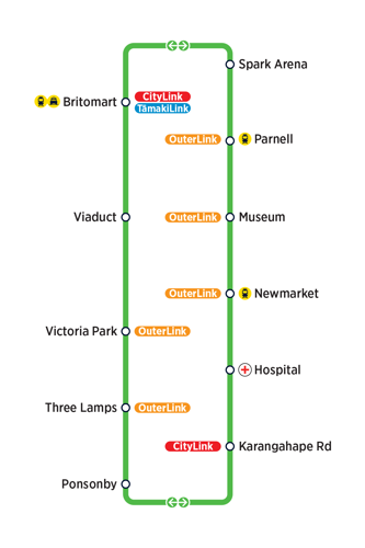
InnerLink - bright green buses
The easy way to get around the inner city is using the local bus routes.

TamakiLink - bright blue buses
The easy way to get to and from the Eastern Bays.
FAQs
Please reach us at info@mtedenmotel.co.nz if you cannot find an answer to your question.
-
Stop N Save Superette: 413 Mt Eden Road, Mt Eden, Auckland, 1024
-
Google maps. Gives real time bus timetable to help explore Auckland City.
-
Stand on the footpath at the designated bus stop. Many stops are serviced by more than one bus route, so make sure you watch carefully for your bus. The destination sign above the bus front window shows the route number and destination. Some buses have destination information on a board placed in the window.
If the bus approaching your stop is the one you want, remain on the curb and indicate to the bus driver, by a clear wave of your arm, that you intend to board.
-
Your card is quick and easy to use. Just tag on at the start of your trip, and tag off at the end. Your fare will be automatically deducted from your card’s balance.
-
If you're travelling with someone without an AT HOP card or contactless method of payment on a train or a bus, you can also use your HOP Money to buy a paper ticket for them. Just let your bus driver know when you board and full cash fare price applies.
-
You can view your remaining AT HOP credit in the AT Mobile app. The app also helps you plan and track journeys across buses, trains, and ferries in Auckland. You'll also get information on bike and scooter hire, disruptions, and the best ways to get around on foot.